About OFFROAD ATLAS
Offline GPS enabled US National Forest Motor Vehicle Use Maps. Save the trails by staying on them. Save the forests by printing less maps. OFFROAD ATLAS allows you to safely explore our National Forest land, even offline.
Offline GPS enabled US National Forest Motor Vehicle Use Maps.
Save the trails by staying on them.
Save the forests by printing less maps.
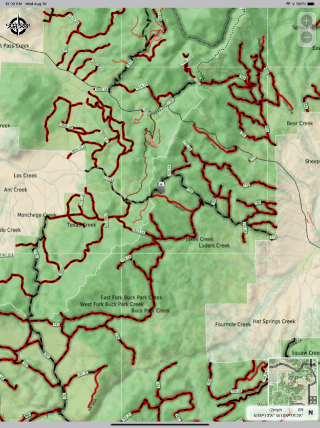
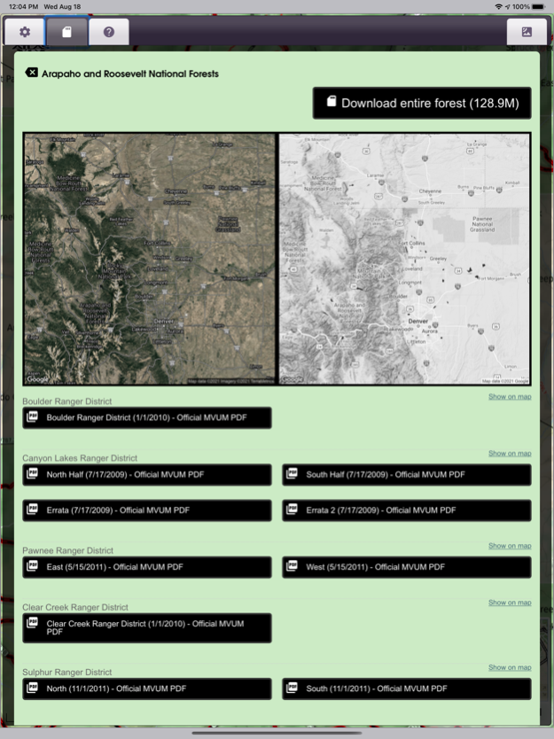
OFFROAD ATLAS allows you to safely explore our National Forest land, even offline. The app shows your GPS location on our seamless Motor Vehicle Use Map (MVUM) to help you identify roads, stay on trails, obey use classifications, and navigate alternative routes in and out of the forest. We also offer quick access to the official MVUM PDFs.
What is a MVUM? It is a map that shows where you can legally operate a motor vehicle on National Forest land. OFFROAD ATLAS uses your phone’s GPS to show your location on our seamless map. We combine the MVUM with other data such as local roads and our map is easily downloaded for offline use.
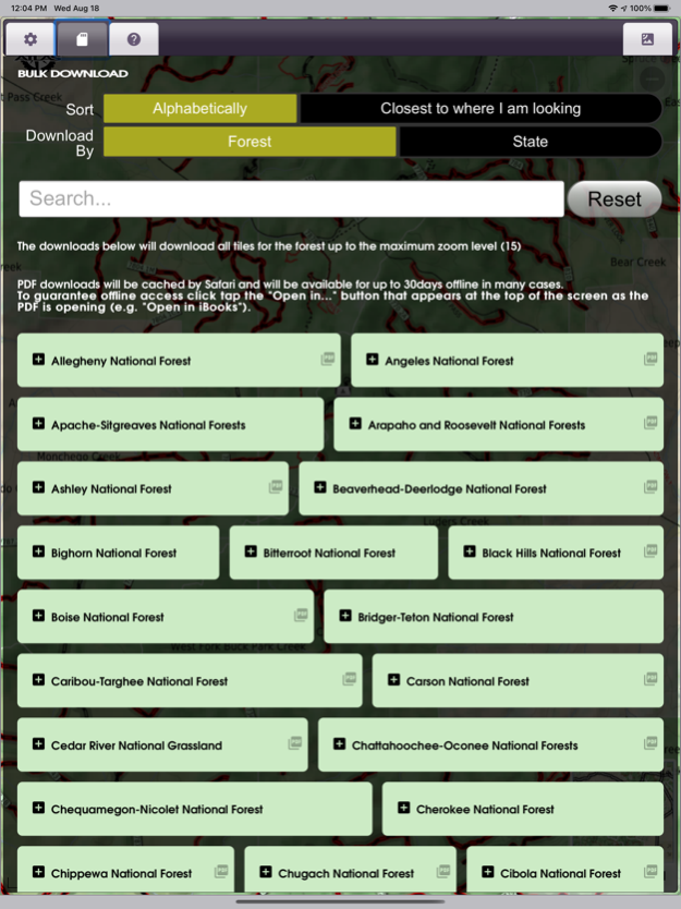
You may browse the map while you have wifi or cell service and OFFROAD ATLAS will automatically download any of the areas you view for offline use when you don't have network access. You may also bulk download any of the areas you plan on visiting.
Always have as much information as possible, please consult the published (printable) PDF Motor Vehicle Use Maps available for any individual forests you plan on visiting to get the latest dispersed camping allowances, seasonal closures, and any other relevant information. As always, be careful, many trails and roads are not suitable for passenger car travel. Some are only traversable in the most capable off road vehicles by the most experienced drivers.
Have fun, be safe, and respect the trails.
OFFROAD ATLAS makes no warranty, expressed or implied, including the warranties of merchantability and fitness for a particular purpose, nor assumes any legal liability or responsibility for the accuracy, reliability, completeness or utility of these geospatial data, or for the improper or incorrect use of these geospatial data. These geospatial data and related maps or graphics are not legal documents and are not intended to be used as such. The data and maps may not be used to determine title, ownership, legal descriptions or boundaries, legal jurisdiction, or restrictions that may be in place on either public or private land. Natural hazards may or may not be depicted on the data and maps, and land users should exercise due caution. The data are dynamic and may change over time. The user is responsible to verify the limitations of the geospatial data and to use the data accordingly.
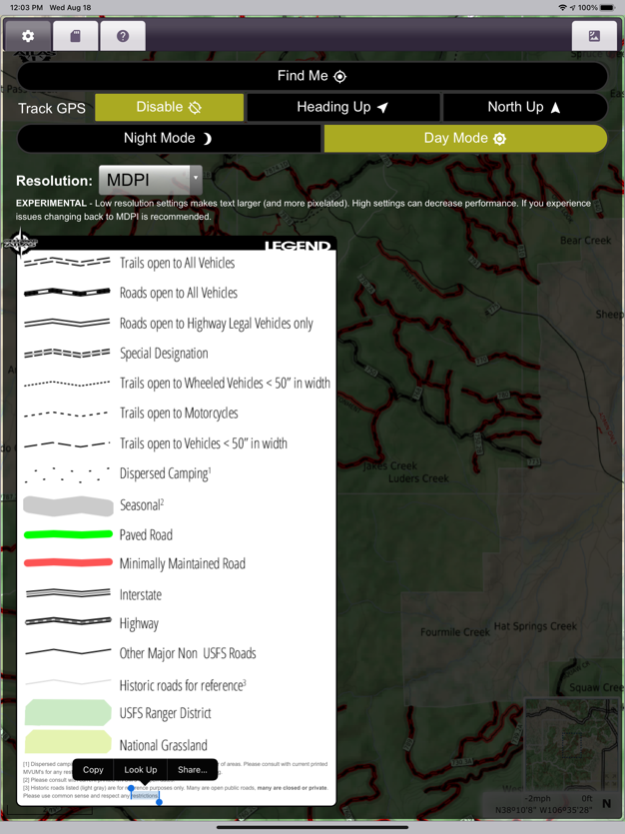
The OFFROAD ATLAS map service depicts Forest Service roads and trails that are designated for motor vehicle use under the official U.S. Government Code of Federal Regulations for identifying designated roads and trails (36 CFR 212.56). Road and Trail MVUM. Additional roads, such as highways, county roads or public roads, are included for mapping purposes. This map service shows the specific types of motorized vehicles allowed on the designated routes and seasonal designation. Data used in this map service are designed to be consistent with the MVUM (Motor Vehicle Use Map). The road and trail data are compiled from the GIS Data Dictionary data and Infra tabular data that the U.S. Forest Service administrative units have prepared for the creation of their MVUMs. This data is published and refreshed on a unit by unit basis as needed and approved by the individual units in order to stay in sync and consistent with the published MVUMs. Interstate, Highway, Other Major Non USFS Roads, and Historic roads for reference are for mapping purposes only and should not be relied upon for their availability for motorized use.
U.S. Geological Survey National Hydrography Dataset, U.S. Department of Transportation Federal Highway Administration HPMS, and various USDA Forest Service datasets used in compiling this information.
Aug 18, 2021
Version 1.7.3
Performance and UX improvements. Various bug fixes.
v1.6:
More seamless National Forest Motor Vehicle Use Map (MVUM) data coverage showing forest roads and trails for off road/OHV use, satellite imagery, seasonal dates, performance enhancements and a few bug fixes.
Previous Versions
Here you can find the changelog of OFFROAD ATLAS since it was posted on our website on 2016-10-14 15:19:25.
The latest version is 1.7.3 and it was updated on 2024-04-22 16:16:37. See below the changes in each version.
OFFROAD ATLAS version 1.7.3
Updated At: 2021-08-18
Changes: Aug 18, 2021
Version 1.7.3
Performance and UX improvements. Various bug fixes.
v1.6:
More seamless National Forest Motor Vehicle Use Map (MVUM) data coverage showing forest roads and trails for off road/OHV use, satellite imagery, seasonal dates, performance enhancements and a few bug fixes.
OFFROAD ATLAS version 1.6
Updated At: 2016-05-19
Disclaimer
Official App Store Link
We do not host OFFROAD ATLAS on our servers. We did not scan it for viruses, adware, spyware or other type of malware. This app is hosted by Apple and passed their terms and conditions to be listed there. We recommend caution when installing it.
The App Store link for OFFROAD ATLAS is provided to you by apps112.com without any warranties, representations or guarantees of any kind, so access it at your own risk.
If you have questions regarding this particular app contact the publisher directly. For questions about the functionalities of apps112.com contact us.